Program Summary
The California Ricelands Waterbird Foundation creates habitat enhancement opportunities for waterbirds and other riceland dependent wildlife. We currently help implement the California Winter Rice Habitat Incentive Program, administered by the California Rice Commission with funding from the California Department of Fish and Wildlife.
This program supports winter flooding of rice fields in California. In a normal year, winter-flooded rice fields create nearly 300,000 acres of wetland habitat in the Sacramento Valley, supporting 7-10 million migratory waterfowl and shorebirds each winter. But as water costs rise, more rice producers are turning to other methods of managing post-harvest straw, leading to less winter flooding — especially in areas where water is most expensive.
To help reverse this trend, the program pays incentives to rice producers who continue winter flooding, helping keep this practice viable for landowners while sustaining critical habitat for waterfowl and other birds in the Pacific Flyway.
Key Program Details
- Flooding period: 70 continuous days between October 15 and March 15.
- Rice: Fields must be planted to rice in 2026.
- Payment Rates:
- $15/acre on the East Side of the Valley
- $30/acre on the West side of the Valley
- Water Depth: continuous flooding of 1-12 inches
- Minimum size: 40 acres
- Field Treatment: Any combination of the following post-harvest straw treatments will be accepted: bale, burn, chop, roll, stomp, a single pass by a disc or chisel pass, or no treatment
- Property Access: To ensure compliance, enrolled fields will be monitored with both in-person visits and satellites.
- Application Acreage Limit: 1,000 acres.
Ineligible Applications
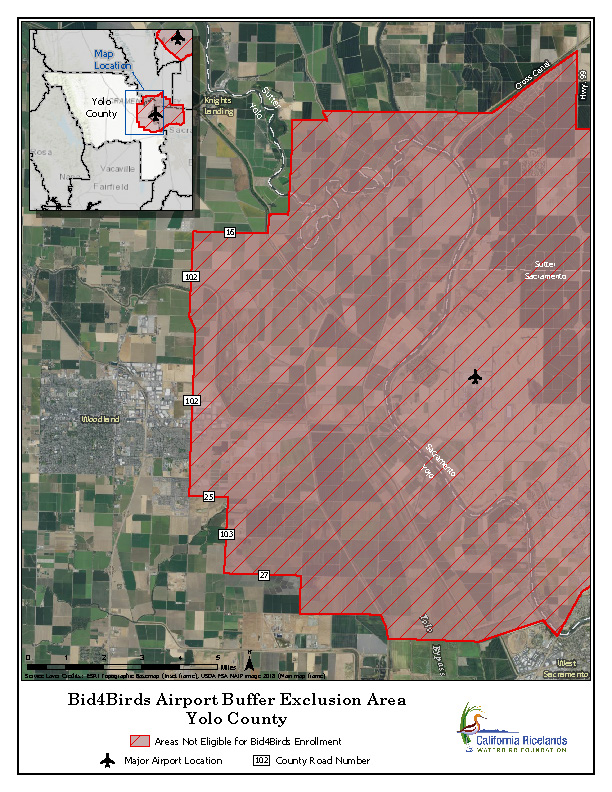
- Properties within 5 miles of Sacramento International Airport and Beale Air Force Base are excluded. Please see maps below.
- Fields that did NOT grow rice in 2026, including fallowed rice fields.
Payment Structure
The California Winter Rice Habitat Incentive Program will have two fixed rate incentive payments based on location within the Sacramento Valley.
Standard Payment: $15/acre
The Standard Payment is for rice producers on the East side of the Sacramento Valley. The East side is defined as the following Counties: Butte, Yuba, Placer, Sacramento, San Joaquin and part of Sutter (all lands East of the West Levee of the Sutter Bypass, including everything within the bypass).
Enhanced Payment: $30/acre
The Enhanced Payment is for rice producers on the West side of the Sacramento Valley. The West side is defined as the following Counties: Glenn, Colusa, Yolo and part of Sutter (all lands West of the West Levee of the Sutter Bypass).
Field Conditions
Fields must be planted to rice during the 2026 growing season to be eligible for this program.
Post-Harvest Treatments
We will accept any combination of the following post-harvest treatments for this program: bale, burn, chop, roll, stomp, a single pass with a disc or chisel, or no treatment. Although we will accept light tillage, such as a single pass of a chisel or disc, we will not accept heavy tillage. Waste grain is an important food source for waterfowl and deep tillage can bury a significant amount of the grain left after harvest. In order to be considered for this program, do not use heavy tillage prior to flooding.
Water Management
Ranking and Scoring Process
- Pass – Field(s) in application were farmed for rice in 2026 and have the potential to be flooded during the winter in Proposed Flooding Period.
- Fail – Field(s) in application were not farmed for rice in 2026 and/or do not have potential to be flooded during the winter in Proposed Flooding Period.
2. Winter Water Reliability and Availability (max. 10 points):
- (10 points) Property has access to maintenance water (via a water district or property-specific water rights) that will ensure it can be flooded during the entirety of the proposed flooding time period.
- (5 points) Property has access to maintenance water (via a water district or property-specific water rights) that will ensure it can be flooded for 50% or more (but less than 100%) of the proposed flooding time period.
- (0 points) Property has access to maintenance water (via a water district or property-specific water rights) that will ensure it can be flooded for less than 50% of the proposed flooding time period.
3. Connectivity and Compatibility with Surrounding Habitat(s) and Landuses (max. 20 points):
Note: Assessment of surrounding land uses will include areas within one-half mile of field border and use crop data from 2-3 years prior to current year.
- Wetland habitat (20 pts.) X ____ % border = ____ pts.
- Rice/Corn (20 pts.) X ____ % border = ____ pts.
- Other compatible land uses including natural habitats such as grasslands (10 pts.) X ____ % border = ____ pts.
- Non-compatible land uses including urban centers, alfalfa, potatoes, winter cereal grains, cover crops, irrigated pasture, riparian corridors (0 pts.) X ____ % border = ____ pts.
4. Proximity to Permanently protected wetland that is managed as a Sanctuary/Closed Area with maintenance-only disturbance (max. 20 points):
- (20 points) Property is located within 5 miles of permanently protected wetland that is managed as a sanctuary/closed area.
- (10 points) Property is located within 5 miles of permanently protected wetland that has maintenance-only levels of disturbance outside of waterfowl season.
- (0 points) Property is located greater than 5 miles from permanently protected wetland that is managed as a sanctuary/closed area.
5. Basin/County priority (max. 30 points):
- (30 points) Property is located within a county that has been documented to have <50% of harvested rice fields flooded during winter months. (Colusa, Glenn, Placer, Sacramento, Sutter, Yolo)
- (15 points) Property is located within a county that has been documented to have 50-75% of harvested rice fields flooded during winter months. (Butte)
- (0 points) Property is located within a county that has been documented to have >75% of harvested rice fields flooded during winter months. (Yuba)
6. Proposed Flooding Period (max. 20 points):
- Landowner will flood all the of the proposed acres for a 70-day period during the following windows:
- Jan 1 to Mar 12 == 20 points
- Dec 15 to Feb 23 == 14 points
- Dec 1 to Feb 9 == 7 points
- Start 70-day Proposed Flooding Period prior to Dec 1 == 0 points
7. Delay of Water on the Landscape (max. 10 points): If your 70-day Proposed Flooding Period starts after Dec 1, are you willing to wait to flood up until Dec 1 or later?
- If yes, 10 points
- If no, 0 points
8. Post-harvest manipulation (max. 15 points):
- (15 points) Landowner is willing to flood some or all of proposed parcel(s) without incorporating stubble via discing/chiseling.
- (15 points) Landowner is willing to stomp flooded fields.
- (0 points) Landowner is not willing to flood parcel(s) without incorporating stubble via discing/chiseling, and is not willing or able to stomp.
9. Shape of Fields (max. 5 points):
Research on bird response to this program recently revealed that fields with interior checks that are more square, than long and narrow, are preferred by waterbirds (ducks, shorebirds, cranes, etc.). The Shape Index is calculated using the area and perimeter for each check in each field, using the most up-to-date aerial imagery publicly available. For each field in your application, we will calculate the average Shape Index of all the checks in the field. We will then calculate an average Shape Index for your whole application and award the following points:
- (5 points) Proposed fields in application have average Shape Index between 1 and 1.14
- (4 points) Proposed fields in application have average Shape Index between 1.15 and 1.28
- (3 points) Proposed fields in application have average Shape Index between 1.29 and 1.42
- (2 points) Proposed fields in application have average Shape Index between 1.43 and 1.56
- (1 points) Proposed fields in application have average Shape Index between 1.57 and 1.70
- (0 points) Proposed fields in application have average Shape Index greater than 1.71
County Exclusion Area Maps